 |
| Arrow points approximately to our location! |
This was a deep earthquake--24.3 km. A M3.5 aftershock occurred less than 2 minutes later at a depth of 30.1 km, within the crust of the North American plate. There have been no reports of injuries, and a few reports of cracks in foundations near the epicenter. The quake was not on the Cascadia subduction zone. The Nisqually earthquake of 2001 with M6.8 near Olympia was in the subduction zone and was within the Juan de Fuca plate.
There is an excellent summary of the types of earthquakes that occur in the Pacific Northwest here. As of 10:30 PDT this morning, there have been a number of small aftershocks.
The nearest big fault is the South Whidbey Fault, which runs southeast from the Strait of Juan de Fuca toward Monroe (to the south of Monroe). The motion along this fault is strike-slip/reverse thrusting. According to UW seismologist Bill Steele, it looks like the quake originated "from a cluster of faults running north-south from Duvall", that is, it was not along the South Whidbey Fault. In 1996 a M5.4 earthquake near Duvall caused millions in damage, but that quake was shallower as well as stronger than this one. In a video on this King5 site, he explains that the motion was tensile, that is, the ground pulled apart. The Early Warning System gave 3-4 seconds warning in Seattle.
Here is a short article on the South Whidbey Island fault zone from the Department of Natural Resources, WA. And, below is a reproduction from the University of Washington website on the South Whidbey Fault:
"Much
of the Southern Whidbey Island fault zone (SWIF), which runs in a
north-westward
direction from Woodinville to near Port Townsend, Washington, remains
mostly
hidden. Geologists conclude that the SWIF is capable of producing a
M6.5 to
M7.4 earthquake (Kelsey et al., 2004).
The ground shaking expected for a M7.4 earthquake is shown in
the
ShakeMap below. As with other crustal faults, any moderate or large
earthquake
on the SWIF will likely be followed by numerous felt aftershocks, some
that
could be damaging, and hundreds to thousands of smaller ones detectable
only by
sensitive instruments.
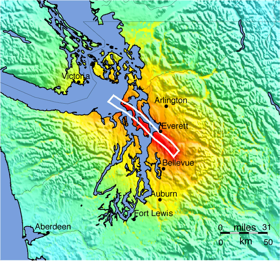 |
|
‘ShakeMap’ showing the
intensity of ground shaking (colors) expected for a M7.4 earthquake on
a segment of the South Whidbey Island fault (white line indicates
intersection of the causative fault with the surface), overlain on
topography.
|
"The SWIF was first discovered because
movements along it juxtaposed older crystalline bedrock next to younger
volcanic basalts (Johnson et al., 1996). These rocks have contrasting
densities and magnetic properties that were measured and mapped by
Gower et al. (1985), and attributed to motions along a single fault.
Subsequent studies showed that numerous fault strands comprise the
SWIF, located within a 6-11 km (3.7-6.8 mile) wide band.
"These faults dip steeply to the
northeast
and have had north-side-up and lateral displacements, and are visible
at the Earth’s surface only about every 35 km (22 miles).These studies
used seismic reflection data, sea cliff exposures, and sparse borehole
data to map the SWIF to the eastern Strait of Juan de Fuca (Johnson et
al., 1996), while others used seismic imaging methods to steer the
fault along the northwestern margin of the Port Townsend basin, where
it may merge with the Darrington-Devils Mountain fault zone near
Victoria, British Columbia (Broker at Al, 2005; Ramachandran et al.,
2005). If these
interpretations are correct, the
SWIF
extends a minimum of 150 km (92 miles) from Victoria, British Colombia,
to near
Woodinville, Washington.
"Evidence
that the SWIF has been recently active comes from high-resolution
seismic images
and measurements documenting uplift of the shorelines that straddle the
faults,
along two coastal marshes on Whidbey Island, at Hancock Lake on the
south side
of the SWIF and Crockett Lake on the north side (Kelsey et al., 2004).
If no
movement on the fault strand occurred in the latter part of the last
10,000
years (Holocene epoch) both sites should have comparable sea-level
histories.
However, stratigraphic observations and radiocarbon dates used to
construct
relative sea level curves for each site diverge between 2800 and 3200
years
ago, suggesting uplift of about 1 to 2 m (3.3 to 6.6 feet) along the
north side
of the fault strand. This amount of uplift was likely generated by a
M6.5 to
M7.0 earthquake, according to empirical relationships between vertical
displacement versus magnitude for historical earthquakes (Kelsey et
al., 2004).
"Earthquakes
on the SWIF probably caused at least three episodes of strong ground
shaking
and one tsunami in the last 1200 years. Geologists studied the
stratigraphy of
channel bank exposures along the Snohomish River near Everett,
Washington
reveal and infer that a widespread pairing of sand overlain by clay
that
correlates over 20 km2 was left behind by a tsunami surge
across the
delta between 1200 - 1020 years ago (Bourgeois and Johnson, 2001).
Multiple
episodes of strong ground shaking also have been inferred from
liquefaction
features, sand dikes and sand-filled cracks up to 1 m (3.3 feet) wide,
some of
which terminate below and others that cut across the tsunami deposit
and thus,
pre- and post-date it (Bourgeois and Johnson, 2001).
"More
recently studies extend the record farther back in time and southward. These suggest that the SWIF produced at least
four earthquakes since deglaciation about 16,000 years ago, the most
recent
being less than 2700 years ago. High-resolution topography (LiDAR) and
measurements of the magnetic properties of the rocks reveal lineaments
indicative of fault movements. These
show that the SWIF forms a 20 km (12 miles) wide swath of parallel
fault
strands, that project onto the mainland near Everett and continues to
the
southeast towards Woodinville (Blakely et al., 2004; Sherrod et al.
2008). The most prominent feature, the
Cottage Lake
lineament, extends at least 18 km (11 miles) and lies on strike with
the SWIF
on Whidbey Island. Excavations across visible scarps that exhibit
north-side-up
vertical relief of 1-5 m (3.3 to 16.4 feet) show these were created in
multiple
earthquakes that post-date deglaciation.
"Although
highly speculative, geologists have suggested that the SWIF is part of
a larger
system of faults that extends from Victoria, reddish Columbia to
Hanford,
Washington a distance of about 385 km (236 miles). However, while such
a system
may reflect very large-scale geologic processes, no evidence exists
indicating
multiple zones have failed together in a single earthquake. A series of
faults
and folds in the Snoqualmie area of the Cascades likely correlate with
the SWIF
(Dragovich et al., 2007, 2008), merge with mapped faults on Rattlesnake
Mountain (mapped by Tabor et al., 2000) near North Bend and continue
southeast
into the Cascade Mountains. Others suggest that faults in the Yakima
fold and
thrust belt correlate with faults west of the Cascades, based on
lineaments in
magnetic measurements and other observations (Blakely et al., 2009).
"The
HAZUS program provides quantitative estimates of some of the impacts of
a M7.4
earthquake on the SWIF. Examples include
~97800 buildings (~5% of the inventory) at least moderately damaged,
with 6% of
these damaged beyond repair. A handful
of bridges will be destroyed completely, significant fractions of the
utility
system will be only partially functional in the first day after the
earthquake
but mostly fixed within a week. However,
in excess of 100,000 households will be without potable water or power
in the
first day and tens of thousands still without both after a week. Almost 14,000 households will be displaced
and 58% of these will require public sheltering. Fatality
estimate
range
from
90
to
432
depending
on
the
time
of day the earthquake strikes.
Economic losses will be in the range of many
billions of dollars."


